ITINERARY
Day 0
El Chaltén is our meeting point and where the trip gets started. The youngest town in Argentina, founded in 1985. The guide will check everybody’s gear, also we will be briefing the trip, the Continental Ice Field characteristics, and get any last minute details sorted.
Day 1
We take a private bus to Puente del Río Eléctrico (Bridge), where our expedition kicks off. We hike for 2 hours through Lenga and Ñires forest. We pass by Piedra del Fraile hut and camping ground; our last contact with civilization for few days. Leaving the camping and forest behind, we keep hiking in a U-shaped glacier created valley, most of the time on a moraine terrain. After an hour’s hike, we run into Pollone Valley where we have to wade the Río Pollone; sometimes this is an adventure in itself. We follow Rio Eléctrico until its first beginnings: “La Playita” Camp, a river bed that Río Eléctrico has left for us to camp on. We’ll find rock protection for our tents. After a rest or, even better, a meal, we hike to Marconi’s snout to check the next day’s route. Altitude gained 100 meter, 14 km, and approx. 6 hours.
Day 2
Today is the key day of the expedition. Glacier Marconi is one of the accesses to the Ice Cap. Most winds and weather come from west/north and funnel through passes like this one. Therefore, weather/wind permitting, we get up early, have breakfast and break down camp. Depending on glacier conditions, the guide will decide which route to take between Laguna de los Catorce with a tyrolean crossing, or through Marconi. We get on Marconi Glacier, a combination of bare ice and rock at first. We make our way to the base of “Cambio de Pendiente” (change of gradient). We rope up, put harness and crampons on. After a section of 40 to 45 degrees and 1 hour on the ice, we reach Marconi Pass. A breath-taking view of the 3rdlargest fresh-water ice mass in the world just in front of us! We appreciate Kolliker Range, Lautaro Range, Gaea Range and Mariano Moreno Range. Walking 1 ½ hour mainly flat on the pass, we step into Refugio Gorra Blanca or Refugio Garcia Soto, a Chilenean Institute of Hielo Patagonico Sur Studies hut. Depending on availability, we might sleep inside or camp outside the hut. Eat, drink and sleep. 800-meter altitude gain, 14 km, 8 to 10 hours.
Day 3
Summit day! Early wake up call. Light backpack only stuff for the day. Our goal is Gorra Blanca’s summit. We make our way through seracs and crevasse aiming for the west ridge. After getting on the ridge, we head east zigzagging ice mushrooms (interesting formation of ice with wind, similar to Cerro Torre summit). Our guide might fix the last pitch to the summit. If weather is good, you won’t believe the view. Cautiously, head back to hut/camp to celebrate an exhilarating day out. 1200 altitude gain, 8 to 12 hours depending on snow conditions and fitness of guests.
Day 4
A good rest day is welcome here!
Day 5
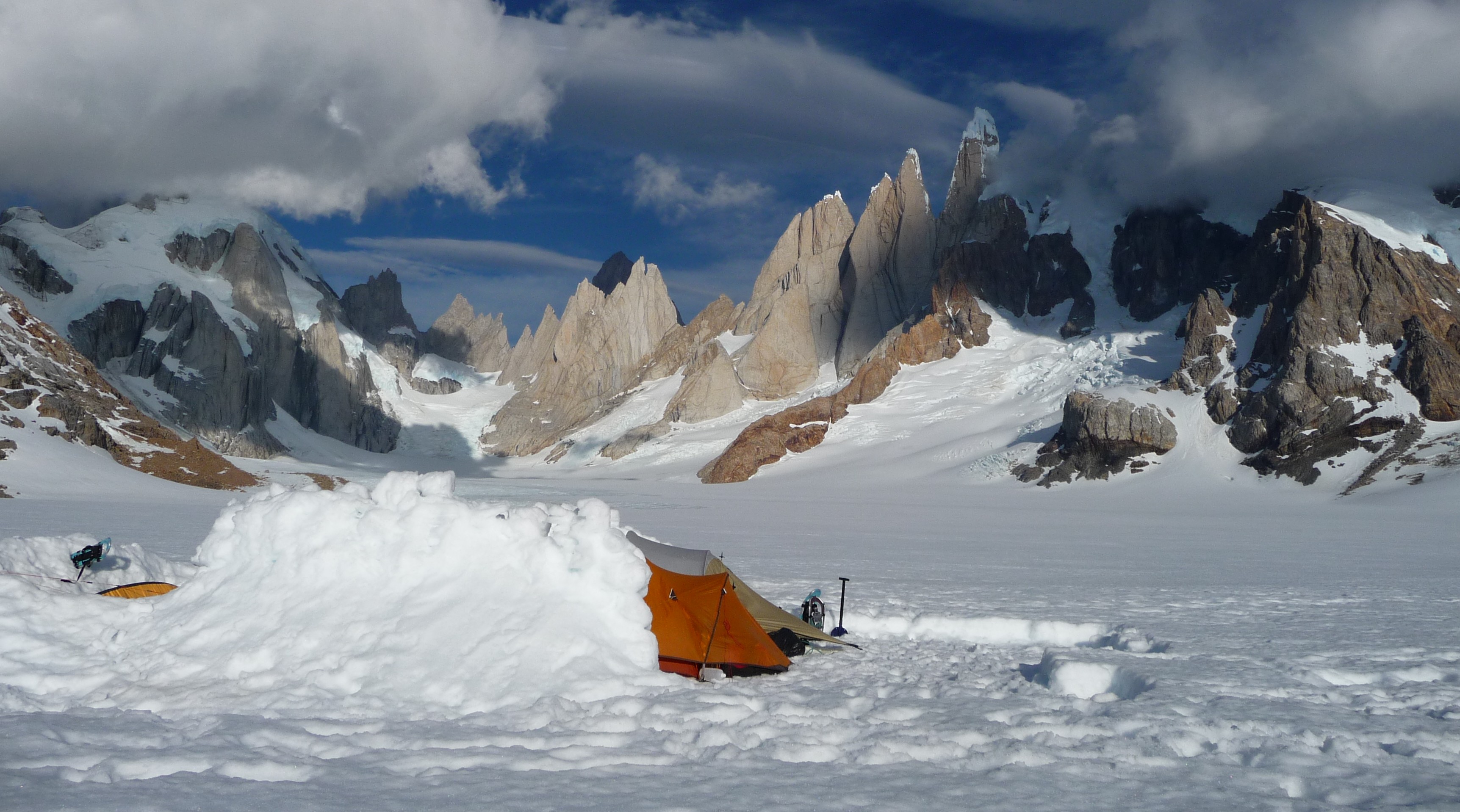
Everything packed and ready to go, we bear south for about 6 hours towards “El Circo de los Altares” (A bowl formed by the west faces of Cerro Torre and its satellite needles.) We will be camping at the entrance of the bowl. Amazing views. Only the ones who get here and are lucky with weather get the chance to see this. We might spend a good time building ice walls to protect our tents from predominant north and northwest winds. 6 – 7 hours, 50-meter altitude gain, approx 15 km.
Day 6
Depending on weather and the physical state of the clients, we might stay one more day at this camp. We take advantage and hike all the way inside the Cirque, getting to the foot of Filo Rosso, beginning of Casimiro Ferrari route of Cerro Torre. It’s just amazing to think they first climbed this route in 1974! Back to Camp.
Day 7
A full day ahead! Today we’ll be walking on snow, bare ice, rock and grass! We leave from Circo de los Altares to Refugio Paso del Viento. We get off the ice around Vivac Laguna de los Esquies and keep walking passing by Laguna Ferrari and Vivac Ferrari. We start to see Mascarello range, a restricted reserve of Los Glaciares National Park. One more hour to the rustic hut of Paso del Viento. We use only the hut for cooking and we sleep in the tents.
Day 8
We contour around Cerro Huemul, always having Glacier Viedma on our right. Alpine meadows, glacier erosion terrain delights us along the way. By the end, only 400-meters elevation separates us from Paso Huemul. Impressive view, one side Lago Viedma, in the other Glacier Viedma! Walking down and some bush waking make us reach Huemul pass Camp. After pitching camp, a five-minute walk delights our eyes: Viedma Glacier face falling into Lago Viedma. Only fifteen more minutes away, a cliff of 500 meters we find condors nesting. 6 hours of walking time. 500 meters of elevation gain.
Day 9
From now on everything down hill! 500 meters of steep down hill, so the rule is: your butt touches the ground; you buy a beer/drink for the group! Down on the flat we’ll be walking on the step by Lago Viedma for about 3 hours. We get to Río Túnel and after wading the river, we have 30 more minutes to Túnel Bay, where a minibus ride brings us back to civilization: El Chaltén.


